

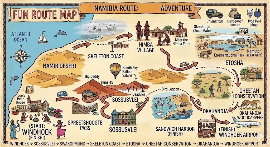
NAMIBIA 13 Days or NAMIBIA EXPRESS 7 Days
This itinerary covers the Sossusvlei dunes in Namib-Naukluft Park, Walvis Bay and Swakopmund, Sandwich Harbour (where the desert meets the ocean), the Skeleton Coast, a Himba village,
Etosha National Park, and a Cheetah conservation center.
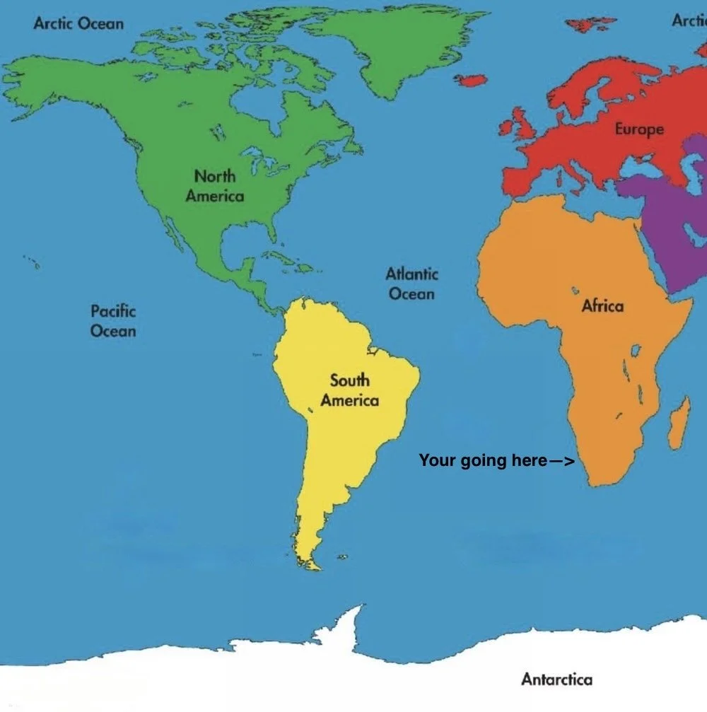
Namibia is in Southern Africa, a bit bigger than Texas, with the Atlantic Ocean to the west.
It has 2.6 million people and a stable parliamentary democracy. The economy relies on farming, herding, tourism, and mining. Namibia is peaceful and mostly safe for travelers to explore.
Its Coastal Desert is one of the oldest deserts, with the world's tallest sand dunes shaped by strong winds.
<The Photo Gallery can be found at the bottom of this page>
Why go?
—With the Atlantic Ocean on one side and the world's oldest desert on the other, Namibia offers a unique experience. Its stunning landscapes feel otherworldly. Highlights include the tall sand dunes of Sossusvlei and Swakopmund, rich native and colonial history, the wildlife hub of Etosha National Park, and many adventure activities.
ℹ️ Essential Tips:
Licensed Tour Operators are a “one-stop” shop offering complete travel/tour services.
🏆 Top choices: Gondwana Travel Centre, Chameleon Safaris, Ultimate Earth, Namibia Tours & Safaris.
Lonely Planet and Bradt Travel Guides are other excellent resources to find a tour operator.
The currency is the Namibian dollar (NAD), pegged 1:1 to the South African rand (ZAR). Both NAD and ZAR are accepted interchangeably across Namibia.
ATMs can be unreliable in remote towns. Carry Namibian cash.
What vaccines do I need?
Namibia is easy to explore by self-drive. You can go anywhere and travel at your own pace.
⚠️ Driving is on the left side of the road. Roads are maintained and well signed. Grab a Namibia Road Map.
When traveling on dirt roads, protect your camera from dust by using a good, dust-proof bag.
Namibians are friendly, low corruption makes it safe and welcoming, and the country has good infrastructure.
Violent crime targeting tourists on self-drive routes is genuinely rare. Instead, criminals focus on non-violent crimes of opportunity. Still, it's wise to follow safety tips, especially because of poverty.The best time to visit Namibia is July through September. The weather is pleasant, rain is unlikely, and
wildlife viewing is excellent. It’s peak season, so book ahead.⚠️ U.S. Canada citizens need a visa for Namibia, but they can easily get an eVisa online before traveling or a
visa on arrival (VoA) at key entry points like Windhoek Airport.
[ENLARGE MAP]
Set out on a 7 or 13-day self-drive journey, where towering red sand dunes meet the Atlantic, and following lions across a vast salt pan is an ordinary afternoon. Explore the Skeleton Coast’s eerie shipwrecks and meet people with strong tribal traditions for an unforgettable, surreal safari.
DAY 1
Arrive at Windhoek Airport and transfer to your hotel.
Windhoek is the capital and largest city of Namibia.
Prep: stock up on snacks and bottled water before your adventure begins.
Dinner suggestion: Visit Joe's Beer House, a legendary Windhoek institution.
Overnight: Windhoek. [where to stay]
Distance: Airport to city, 35 minutes / 40 km.
DAY 2
Start your trip with a stunning drive to Sossusvlei.
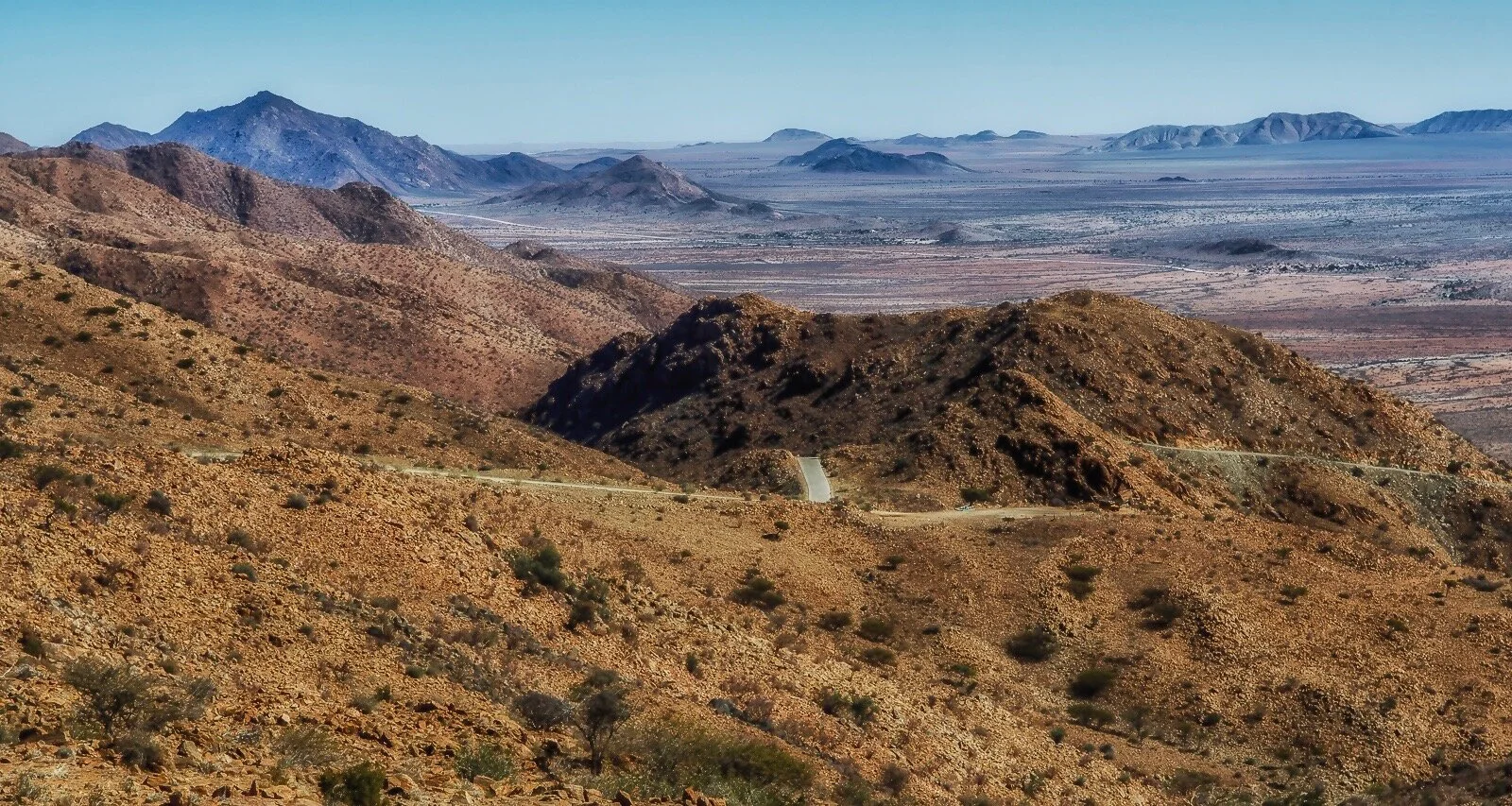
We recommend the Spreetshoogte Pass route to the Dunes.
—It is a gorgeous high mountain pass located in central Namibia.
—The pass is one of southern Africa’s steepest, with a 22% gradient.
—The pass lies on district road D-1275 from Rehoboth to Solitaire.
Overnight: Sossusvlei (3 nights) [where to stay]
Distance:
Windhoek ---> Spreetshoogte, 3 hrs.
Spreetshoogte ---> Sossusvlei, 3.5 hrs.

BE MINDFUL OF YOUR AUTO GASOLINE SUPPLY IN THE REGION. THE ONLY GAS STATIONS ARE AT SOLITAIRE AND AT SOSSUSVLEI. Never pass one without topping up. In addition, they will be able to assist with any tire problems and minor issues.

Map-Dunes, enlarge image
DAYS 3 and 4.
Two action-packed days.
Discover the Sossusvlei Dunes in the Namib-Naukluft Park.
The tall sand dunes are said to be the highest in the world. — The dunes are
about 36 km from the gate.
The first noticeable dune you see is DUNE 45, about 45 km from the entrance.
GPS coordinates: 24.7278° S, 15.4726° E
Further up is the Sossusvlei basin.
—The Dunes you must see: Sossusvlei, Big Daddy, and Dead Vlei.
-
Dune 45 gets its name because it lies 45 km past Sesriem (the entrance gate) into the park. It is 80 meters high and it is composed of 5-million-year-old sands.
GPS coordinate: 24.7278° S, 15.4726° E
It is about 66 km past the Sesriem gate. The last 6 km require a 4WD because the gravel road ends and gives way to sand. Sossusvlei is a clay pan covered by a crust of salty sand.
The river is dry most of the year and, when it has water, it brings little to the vlei (a shallow natural pool). The vlei lies among tall orange-red dunes partly covered with grass, bushes, and a few trees.
GPS coordinate: 24.7274° S, 15.3312° E
Big Daddy is one of the highest dunes in the Sossusvlei area, at about 325 meters. Big Daddy is located near Deadvlei. It faces another very high dune known as "Big Mama".
GPS coordinate: 24.7681° S, 15.3025° E
Deadvlei is another clay pan, about 2 km from Sossusvlei. A notable feature of Deadvlei is that it used to be an oasis with several acacia trees; afterwards, the river that watered the oasis changed its course.
Blackened, dead acacia trees dot the pan, standing out against the bright white salt floor and the deep orange dunes. The result is a striking, surreal landscape often photographed and used in films and videos.
GPS coordinate: 24.7593° S, 15.2924° E
Hiddenvlei (or Hidden Vlei) is the third most famous vlei in the Sossusvlei area. It is 4 km from the car parking, and it is the least visited.
GPS coordinate: 24.7486° S, 15.3356° E
Ballooning - a great way to see the dunes from a different angle. [Namib Sky Balloon Safaris]
If there's time, explore the Sesriem Canyon, a narrow 1 km gorge, 30 m deep — great for walking and viewing rock layers.
Overnight: Sossusvlei region.
DAY 5
Your next destination is the Swakopmund/Walvis Bay area. [map]
Pause for a quick photo at Kuiseb Canyon, a stunning landscape adorned with deep ravines.
GPS coordinate: 23.3667° S, 15.6667° E
Swakopmund - Namibia’s main beach resort is a colonial town with German-style buildings and restaurants. [video]
Swakopmund offers water sports and nearby sand-dune adventures.
You can stay in Walvis Bay, but Swakopmund has a nicer town and atmosphere.
Walvis Bay is 35 km south of Swakopmund, famed for dolphin and seal boat tours and a bird-rich lagoon with flamingos.
(More details are outlined in Day 6)
If you arrive in Swakopmund by early afternoon, you may still have time to go Quad-biking on the dunes.
—Inquire at the local rental shop.
Overnight: Swakopmund. (2 nights)
Distance: Sossusvlei ---> Swakopmund, 6 hrs./ 350 km.
Driving tip: Gas and food stop at Solitaire outpost (about 140 km north of Sossusvlei)
DAY 6
Activities at Walvis Bay / Sandwich Harbor:
The area is rich in birds and has a striking mix of sea and dunes.
Map view of the northern section of Namib Naukluft Park.
At Walvis Bay, see a huge bird colony of about 200,000 birds, including terns, flamingos, and pelicans. You'll often spot large flocks of each.
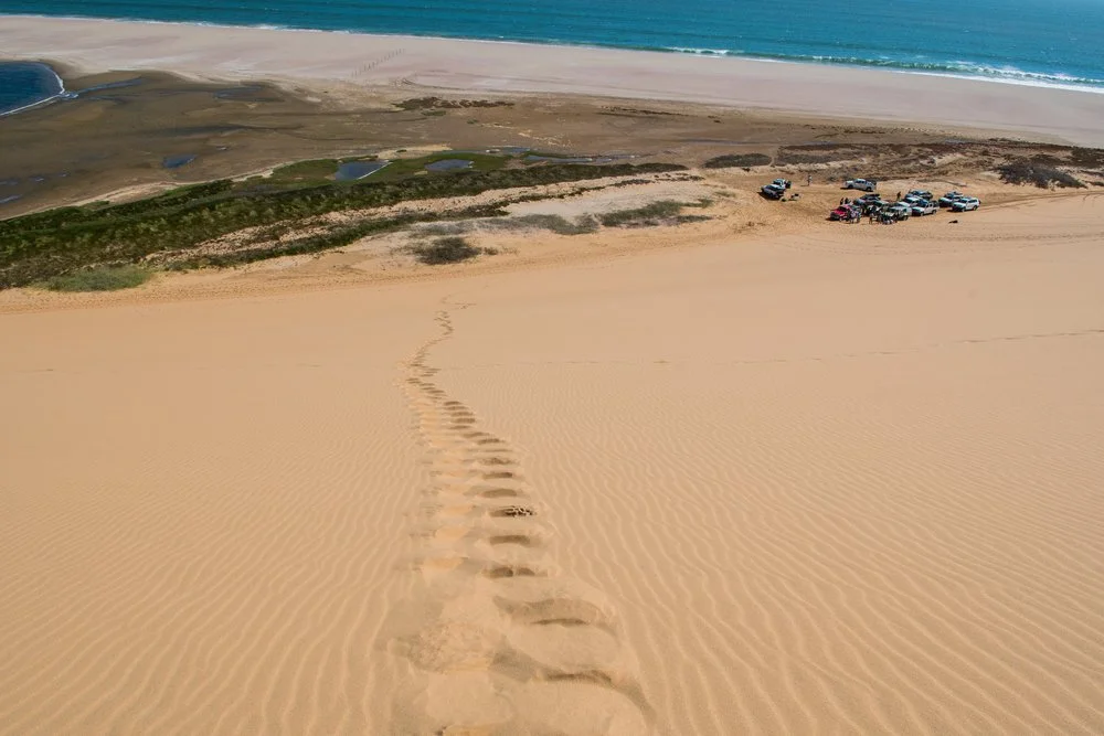
Sandwich Harbor - it’s 50 km south of Walvis Bay and only accessible with a local operator.
Access is with a 4x4 vehicle.
Access to the lagoon can occasionally be hampered by high tide, which means that NOT all scheduled tours are able to reach the lagoon. Visitors may need to walk the last stretch to the lagoon.
GPS coordinate: 23.3501°S 14.5029° E
For an unforgettable adventure, consider booking a guided kayaking tour to see seals at Sandwich Harbor. Many visitors choose to pair this experience with an exciting 4x4 Dune ride near the Atlantic Ocean.
Both the kayaking and the Dune 4x4 ride are highly recommended activities, and you will find many great photo spots: marine life, jackals, and wide, stunning dunes to the deep blue ocean waters.
Overnight: Swakopmund.
Distance: Swakopmund ---> Walvis Bay, 45 minutes.

Go kayaking with thousands of seals off Walvis Bay coast.

Options on Day 7: continue in Nambia, journey to Botswana or return home:
Options on Day 7: continue in Nambia, journey to Botswana or return home:
DAY 7
Depart Swakopmund / Walvis Bay.
<Namibia Express: 7 day itinerary ends here>
⚠️ If your continuing to explore Namibia-13 day itinerary, continue reading:

Departing Swakopmund, head past a section of the Skeleton Coast.
Skeleton Coast Park is one of the world’s last wild places, covering 500 km from Swakopmund to the Angola border and about 40 km across. This remote coast is famous for its eerie beauty, with shipwrecks, cold fog from the Benguela Current, and moving desert sands.
It’s a place of vast desert, eerie isolation, and surreal landscapes—so striking that parts of Mad Max were filmed here. The shipwreck beaches and dramatic inland scenery make it a dream for photographers.
The park is home to over 100 species of lichen, desert-adapted elephants, rhinos, and lions. The Kunene River mouth is a key wetland.
Terrace Bay, the only place open all year that regular cars can reach, has beachfront chalets and is popular with fishermen. Besides fishing and a nearby 4×4 dune ride, there are few activities.
There are two park entrances:
Springbokwasser Gate (via C39 from Damaraland)
Ugab River Gate (via C34 from Swakopmund)
Overnight: Khorixas
Distance: Swakopmund ---> Khorixas, 4 hrs. / 310 km.
DAY 8
Visit the Otjikandero Himba Village for a Himba experience before continuing to Etosha National Park.
The Himba are one of the last tribes in Africa living within their tradition. They are a semi-nomadic people and culturally distinguishable.
To visit the village, contact a tour operator.
The one (1) hour tour includes a variety of ceremonies, farming, smoke baths, and an insight into their lives and traditions. You will be able to interact with the Himba and are free to photograph.
Overnight: Okaukuejo, located 17 km from the South Gate, Etosha N.P.
[Accommodations]
Distance:
Khorixas ---> Himba Village, 90 minutes.
Himba village -->Etosha Park (south gate) 3 hrs.

Meet the Himba Tribe
Getting to the village: Depart Khorixas to Kamanjab, then drive C-40 east for 21 km. Map [DIRECTIONS]

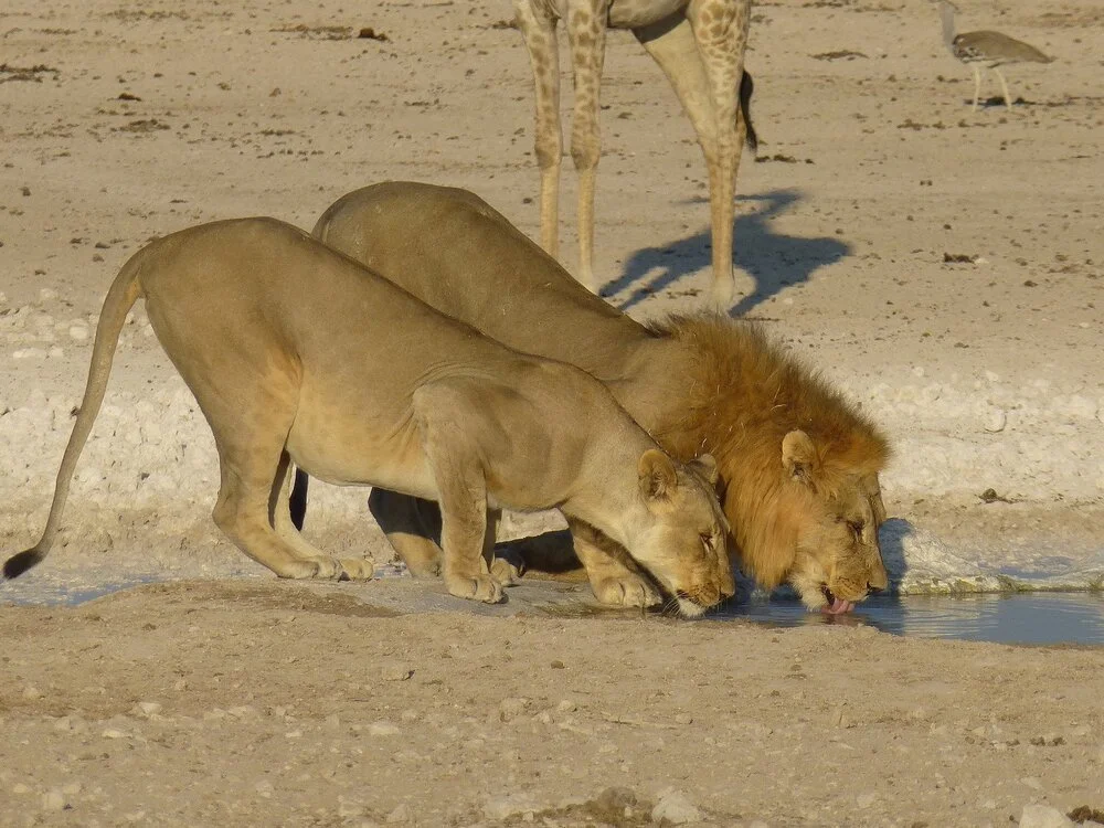
DAYS 9 and 10
Two (2) days at Etosha National Park. [Learn more]
The best game viewing season is May through September. [video]
The camp reception and the game warden are valuable sources of advice for locating the best areas for game viewing.
Etosha is home to a wide array of large mammals, including lions, leopards, elephants, rhinos (although they are rarely spotted), giraffes, wildebeests, hyenas, zebras, springboks, kudus, gemsboks, and elands.
The park's main features are the visible salt pans. The climate is a dry savanna.
The recommended route is to enter at Okaukuejo (south gate) and depart at Namutoni (east gate).
Overnight: on Day 9. Okaukuejo (South gate -Anderson)
Overnight: on Day 10. Namutoni (East gate)

World’s fastest land mammal
DAY 11
Leave Etosha Park (East Gate).
Make a stop at the Cheetah Conservation Fund.
The Cheetah Conservation Fund protects wild cheetahs. Visit to see and learn.
—Located 44 km east of Otjiwarongo on D-2440.Continue to Waterberg Plateau National Park for a brief visit. [directions]
The park is a characteristic table mountain, ecologically diverse with over 200 different species of birds.
Explore the valley of this nature reserve. [Hiking map]
Overnight: Waterberg Plateau N.P. [accommodations]
Distance:
Etosha ---> Cheetah Conservation, 3 hrs./ 300 km.
Cheetah Conservation---> Waterberg Plateau, 2 hr.
DAY 12
Depart Waterberg Plateau N.P.
Stop along the way in Okahandja, where two (2) large outdoor craft markets are located.
These open-air markets are a popular tourist spot in Namibia. Always haggle when buying. They offer a great selection of crafts and souvenirs. The South Market is better.
Afterward, continue to Windhoek.
Overnight: Windhoek
Distance:
Waterberg Plateau ---> Okahandja, 2.5 hrs.
Okahandja ---> Windhoek, 50 minutes.
DAY 13
Depart Windhoek for your flight home.
Option: Many visitors add an extension to Cape Town.
Distance: Windhoek ---> Airport, 40 mins.
Summary: Which itinerary is better for you?
Namibia 7-Day Express: Best for photographers. You get the world-class dunes and the coast, but you leave
before seeing a single elephant or lion. It’s "Namibia Lite."Namibia 13-Day: The true Namibian experience. It includes the "Big Three": Dunes, Tribe, and Safari.
If you have the time, this is the superior choice.
🚗 SELF DRIVE TIPS: Driving on gravel or sand roads.
Most main roads in Namibia are paved, but you will often drive on gravel or sand roads. This is especially true for visitors going to Sossus Oasis, as all roads to Sesriem are gravel. These roads are usually maintained and in good condition, but some parts can be very bumpy.
The best speed is around 80 km (45 mph) per hour. Driving too fast can cause you to skid, like on snow.


-
1. Do I need a converter/ adapter for the electricity?
Namibia uses 220 volts electricity and requires a South African style plug (three large round pin). Travelers will need a voltage converter for 110 volt devices. It is best to travel with your own adapters.
It is not possible to use appliances such as hairdryers or electric shavers in the tented rooms as most of the camps in Namibia have low wattage fuses which will trip.2. Is the water safe to drink?
Tap water is generally safe to drink throughout southern Africa. However, bottled water is readily available and recommended in Namibia and all African destinations.
3. How safe is Namibia?
Namibia is a peaceful country. Some studies show Namibia has the safest country in all of Africa. However, they do have petty crime. Travelers should take the same precautions that they would in a major city in the US. Don't wear expensive accessories or watches, and don't carry large sums of cash.
4. Do the lions or other wild animals roam the city streets freely?
No, they don’t. But in the wild yes. We recommend you be off the roads at sunset.
5. Can I use US dollars, or do I need local currency? What is the local currency, exchange rate, etc.?
The local currency of Namibia is the Namibian Dollar. Namibia banks only accept US Dollars, Pound Sterling, Euro, and South African Rand in cash. Any cash payments made to camps for curios or gratuities need to be in one of these currencies.
Generally, money exchanges and local vendors are the most concerned with the quality of currency. You may have a difficult time exchanging US dollars if they are old or damaged. The general rule is NO bills printed before 2010 and bills that are torn or have writing on them are NOT accepted.
6. What immunizations are recommended/ required?
No immunizations are currently required for visiting Namibia. You should be up to date on our routine vaccinations, including Tetanus. The CDC is currently recommending the following vaccinations: Hepatitis A, Malaria, & Typhoid.
You may also want to consider the following vaccinations: Hepatitis B, Yellow Fever and Rabies.
Please note that some countries, such as Namibia, require a yellow fever vaccination if traveling directly from an affected country (such as Zambia). Please check with the Center for Disease Control for information for your onward travel from Namibia.
For the most current information, please check out the Center for Disease Control.

Search for your hotel


Average cost:
(EXCLUDING AIRFARE)
$$$ USD for two (2) people.
Budget: $3700
Moderate: $5200
Luxury: $6500 +

🌤️ Climate Guide:
Over 300 sunny days a year. Don’t forget your sunglasses!
The hot season and wet seasons are October through February.
Namibia’s dry period and best time to visit are May through September.
The warmest months are November and December.
The coolest and driest months are July and August. It’s the best time to visit.


Namibia Gallery
🎬 Video


Sources: namibia-1on1.com. wikipedia.org, map of namibia.com,NASA photos., etoshanationalpark.org