

Norway, Lofoten Islands 13 Days
The archipelago is famous for its natural beauty, charming fishing villages, fishermen’s cottages (Rorbu), dried fish, and rich wildlife. Small villages with Rorbu are scattered around the islands, many now used as places for visitors to stay. You’ll find beautiful beaches here, though the water is cold. Hiking in summer is the most popular activity.


🇳🇴 Essential Tips:
Travel Guides: Lonely Planet and Fodor’s Norway.
Renting a car is the easiest way to explore the country.
A Visa is not required for USA and Canadian citizens.
Currency: Norway uses the krone, so euros won’t be very useful.
Alert: 💰You don't need to withdraw much cash in Norway. The country is becoming cashless: coins and notes are only 4% of transactions. Credit cards and PayPal are accepted almost everywhere.
Hiking Poles are very helpful on hiking trails.
Poles reduce strain on the body, which helps people with past hip or knee injuries and those carrying heavy packs.
Also, bring sturdy shoes and a windproof jacket.
Drone Regulations: Norway follows EU drone rules: pilots must register if their drone has a camera or weighs over 250g.
For any drone, you must be registered before flying within Norway.
🛸For details and to start registration, go to the Norwegian Civil Aviation Authority website: https://luftfartstilsynet.no/en/drones


Mefjord Brygge

DAY 1
Fly to Bardufoss or Tromsø, then head to your hotel on Senja if you have time.
Tromsø is a 3.5 hr. drive to Senja. (ferry connection)
Bardufoss is a 2-hr drive to Senja (no ferry needed)
If you spend your first night in Tromsø, you’ll be glad you did.
Tromsø feels lively and worldly despite being in the Arctic. The city has excellent restaurants serving seafood and a busy nightlife — it has more pubs per person than any other town in Norway.
Tromsø has long been the launch point for Arctic expeditions, and today it is a great base for winter Northern Lights hunts.
Top attractions in Tromsø.
Overnight: The villages of Mefjordvær or Hamn on Senja Island are the best location(s) to base yourself. (3 nights)
Mefjord Brygge Hotel is preferred.
Hamn i Senja is another good choice.
Distance:
Mefjordvær —> Fjordgard, 35 minutes.
Mefjordvær —> Skaland, 27 minutes.
Mefjordvær —> Gryllefjord ferry port, 70 minutes.
DAY 2 and 3
Senja is Norway’s second-largest island, 250 km north of the Arctic Circle and just north of the better-known Lofoten Islands.
It’s as stunning as Lofoten but far less crowded. Expect dramatic fjords, fishing villages, and mountains — a hiker’s paradise.
Hiking to Senja.

Best Day Hikes on Senja Island:
Husfjellet (Medium difficulty – 7.6 km – 3 to 4 hours)
The trail to Husfjellet starts in Skaland. A steady 630-meter climb with amazing views all the way. One of Senja’s best hikes — great for families.
Segla / Hesten (Medium to Hard difficulty – 3.7 km – 2 to 3 hours)
—The famous photo of Segla—common on social media—is taken from the nearby mountain Hesten. The trail to Hesten is short (less than 2 km to the top),
but steep with an elevation.Trailheads for Segla and Hesten both start in the village of Fjordgård, but at slightly different spots.
Directions: [map]
Mefjordvaer Trail - a 2 km loop trail near the village of Mefjordvaer. An easy route that takes about 45 minutes to finish. You're rewarded with great views of the fjords and the town.
Sukkertoppen trail - A scenic route with great views. The final stretch is steep, but you can stop below the peak if you don't want to go all the way.
Difficulty: moderate, 5 km RT.Senja Island’s coastal roads are part of the National Tourist Route.
A useful app to download before any hike is AllTrails.
Overnight: Senja Island.
Other Highlights:
-
The Tungeneset rest area lies on the tip of the promontory that separates the Steinsfjord and the Ersfjord. A walkway leads out over the rocks to provide a view to the Northern Sea in the west and the mountain (Oksen) with the sharp peaks in the north.
GPS coordinates: 69°29'21.8"N
-
-
Hamn is an idyllic Norwegian fishing village, surrounded by dramatic mountainous scenery. Activities include kayaking, hiking, fishing trips, and wildlife/safari by boat.
Accommodations - you will find the idyllic Hamn i Senja resort here with high standard accommodations and perfect views.
DAY 4
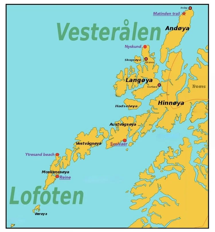
Explore Andoya Island.
Take the earliest ferry from Gryllefjord (Senja) to Andoya Island.
Ferry time: 1 hr. 45 m
If you can do only one hike on Andoya Is. then the Matinden trail should be it.
An eight (8) km (4.6-mile) out-and-back trail near the town of Bleik. Difficulty: moderate. [directions]
A beautiful hike with stunning views of mountains, the coast, sandy beaches, and clear blue sea.
Travel later to Sortland. It is the largest town in the Vesterålen region and makes a good stop to stock up on food and supplies.
Overnight: Sortland
Distance:
Mefjordvaer —> Gryllefjord ferry port, 1 hr. 10 min
Ferry duration: 1 hr. 45 m
Andoya Island ferry port —> Matinden trail parking lot, 15 min.
Matinden hike parking lot —> Sortland, 1 hr. 40 min.

What is a Norwegian Rorbuer?
Rorbuer are now a Lofoten icon. No longer fishermen’s homes, they’re popular places to stay for visitors to the Arctic islands.
Rorbuer are original cabins once used by traveling fishermen, now updated for comfort and giving a sense of life between land and sea.
DAY 5 and 6
First stop is the abandoned fishing village of Nyksund, now being revived as an artist colony.
Nyksund is a pleasant photo stop and worth a quick visit.
Vehicles are not allowed in town. Parking is available just outside of town.
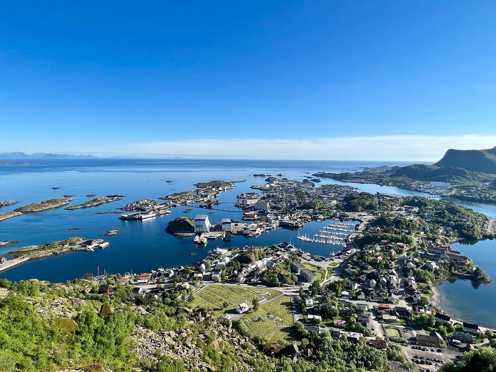
Continue to Svolvaer (overview). Svolvaer is set with a backdrop of high mountains and is the gateway to the Lofoten islands. The main tourist attraction in town is hiking.
Hike to Fløya og Djevelporten.
A tough but rewarding hike with spectacular views. The trail climbs from Svolvær to 600 m in about two hours, offering great views of Svolvær along the way—the famous Svolværgeita (a pinnacle rock which is famous with rock climbers) and the striking Devil's Gate.
The route has some steep climbs and slopes, so you need to be extra careful. The last sections to Fløya are only suitable for physically fit hikers.
Distance: 4.5 km, Difficulty: moderate, Elevation: 580 m, Time: 4-5 hrs.
Getting to the trail: next to the Svolvaer cemetery.
GPS coordinates: 68°14'40" N 14°34'41"E
When visiting the Lofoten Islands, take a boat trip to see the fjords—easy and enjoyable.
🚢 The best-known fjord is the narrow Trollfjord. It’s near the town of Svolvær, where all Trollfjord cruises start.
[Click here] for information on booking a cruise.
Svolvær is a good base with many restaurants, shops, and supplies for trips.
Overnight: Svolvær (2 nights)
Where to stay:
Svinøya Rorbuer (above water fisherman cabins)
Anker Brygge (luxury)
Thon Hotel Lofoten (mid-range)
Scandic Svolvær (mid-range)
Distance:
Sortland —> Nyksund, 1 hr.
Nyksund —> Svolvaer, 3 hrs.

Village of Hamnoy.
This picture of Hamnøy’s red fishermen’s cabins on the seashore has been featured in many magazines and websites, including on the cover of National Geographic and Condé Nast Traveler.
DAY 7
Visit the Lofotr Viking Museum.
In the town of Borg in Lofoten, [map], you can experience the Viking Age in a living environment. Taste the food, hear the stories, and feel the smell of tar and fire.
Continue to Hamnoy, Norway.
⭐ Hamnøy is a tiny, stunning fishing village in the Lofoten islands. Many call it one of Norway’s most beautiful spots. Its red fishermen’s cabins by the sea draw photographers from around the world.
The red cabins (rorbuer) are available. [Reserve here]
You can get that iconic view we mentioned above from the Hamnoy Bridge Photo Spot Viewpoint.
Overnight: Hamnoy (Red cabins recommended)
Otherwise, in the town of Reine, 5 miles away. (2 nights)
Distance:
Svolvaer —> Lofotr Vikingmuseum, 1 hr.
Lofotr Vikingmuseum —> Hamnoy, 1 hr.

DAY 8
Hike the famous Reinebringen trail.
The Reinebringen trail is one of the most popular hikes in all of Norway.
The view, the easy access from Reine, and constant social media posts have made Reinebringen one of Lofoten’s most popular hikes, with hundreds climbing it daily in summer.The weather is the main determinant of when to hike.
Fog, rain, and thick clouds happen often. Be ready to hike
as soon as the weather improves.
The trail has 1560 stone steps. Except for the last 50 meters, the Reinebringen trail is mostly just climbing these stairs.
Go early morning or late evening to avoid crowds.
Remember, the midnight sun exists in the summer, resulting in ample opportunities.
The sun does not set between May 27th and July 17th.
-
Getting There
Reinebringen is located immediately west of the village of Reine, with the stairway beginning on the western side of the Ramsvik tunnel, along the old road.
Parking has become a severe issue since the opening of the stairway in July 2019.
Free parking:
—Djupfjord viewpoint. Located along the E10, 1.3km west of the trailhead. This is the largest free parking in the area.
Paid Parking:
—Ytre Havn, Reine. Located in the outer harbor in Reine, 1.8km from the trailhead. Follow the sign posted ‘P’ after turning into Reine.
—Reine Kultursenter. Located just before the center of Reine.
Note: The Reinehalsen viewpoint at the corner of the E10 and the turn into Reine also serves as a nearby parking area. However, this is intended to be a stopping point for a quick view over the harbor and not a parking lot or campground (No Camping signs have been added in July 2019). It is likely it will be full on any given summer day, but it is still requested that you don’t park here. Parking is limited to 4 hours.

Ytresand beach
DAY 9
Hike the Ytresand til Roren trail. A pleasant family hike.
With only a small amount of elevation gain (365 m) and a good trail, this hike provides fantastic views [photo] over the turquoise waters of Yttersand beach and across to the distant mountains.
Distance: 5 km RT, Difficulty: easy-moderate, Duration: 3 hrs.
Getting there: from the E10, drive in the direction of Fredvang. There is a parking area at the trailhead. GPS coordinate: 68°05'57.2"N 13°08'04.6"E
Stop at the picturesque fishing villages of Nusfjord and Henningsvaer.
Nusfjord once housed about 1,500 fishers, some living in rorbuer (fishermen’s cabins). Many old fishing buildings have been restored. Today, the fish oil factory, blacksmith, boathouses, and other structures show how life used to be.
Nusfjord is now an open-air museum. [Video]Henningsvær is another picturesque fishing village worth visiting. Colorful buildings line the harbor, with quirky cafes and restaurants.
Henningsvær, called "the Venice of Lofoten," lies about 20 km (12 mi) southwest of Svolvær. [Video]
Afterward, continue to Svolvaer.
Overnight: Svolvaer
Distance:
Hamnoy —> Ytresand til Roren trailhead. 25 min.
Ytresand til Roren —> Nusfjord. 30 min.
Nusfjord —> Svolvaer. 2 hrs.
DAY 10
Travel to Oslo, Norway.
The main airport in the Lofoten Islands is Svolvaer (SVJ) Airport.
Other nearby airports include: Evenes (EVE) (165 km) and Bardufoss (BDU) (300 km). [Airport locations]
This itinerary started at either Tromsø or Bardufoss airport. Returning to Oslo from a different airport may increase costs because
of one-way car rental drop-off fees. Choose based on your travel budget.Returning to Tromsø takes almost a full day of driving, so factor that into your plans.
Evenes and Bardufoss airports are nearby — about a three-hour and four-hour drive, respectively.
Overnight: Oslo (3 nights)
Getting from Oslo airport to downtown Oslo:
Flytoget airport express trains depart every ten (10) minutes daily and take only 20 minutes to get to Oslo Central Station.
Oslo Central Station is the main railway station in Oslo and close to hotels and downtown attractions.
Uber - more expensive.
Map of Oslo.


DAYS 11 and 12
Oslo highlights:
Oslo’s public transportation system is Ruter. [route map] Ruter is the best way to get around the city. Most attractions are nearby, so you can see a lot by walking or biking.
A car rental is not necessary for visiting Oslo.
Don’t miss Aker Brygge. Centered on an old shipyard, this area is the city's heart. Busy day and night, it features striking architecture. About 12 million people visit Aker Brygge each year for its waterfront boardwalk, upscale shops, great restaurants, and cozy patio bars with fireplaces open year-round.
Vigeland Sculpture Park, located in Oslo’s famous Frogner Park, is one of Norway’s top
tourist attractions.Open year-round, this sculpture park is Gustav Vigeland's life’s work and features 250 lively sculptures in bronze, granite, and iron.
Visit Oslo's new National Museum. The museum houses collections from the National Gallery and
the National Museum, plus contemporary art and design.If you’re a museum lover, then the Munch Museum is another “must-see”.
The museum honors Norway's greatest painter, Edvard Munch (1863–1944), and holds a large collection of his paintings, prints, drawings, watercolors, and sculptures.
Visit the Oslo Opera House.
The Opera House has become popular due to an odd reason. From the ground, the roof of the Opera House slopes steeply up, creating an expansive walkway past the high glass windows of the interior foyer. Clad in Italian marble and white granite, visitors can stroll up the incline, walk on the roof, and enjoy views of Oslo and the fjord.
If you are visiting in August, enjoy the month-long Festival of Chamber Music, which includes dozens of chamber music concerts.
[Learn more]Hop-On, Hop-Off Bus Tours:A smart, convenient choice for travelers—perfect sightseeing without the hassle of research, effort, or planning.
Runs daily April 1–September 30. Boarding: get on at any bus stop.
Oslo’s nightlife: Oslo’s bars and clubs, famous for live music, stay open until 3 a.m. and are usually within walking distance.
Start your evening in the Grünerløkkahipster district; this renovated district has quite a few great places to grab a few drinks, like
Blå & Bortenfor, which are easily located right next to each other.Grünerløkka has become one of the trendiest districts of Oslo. It has become a hub for independent art galleries, cool bars, and trendy restaurants. With beautiful greenery and a vibrant cultural scene, Grünerløkka is a place not to miss.
Another popular nightclub is “The Villa”. It’s open only on Friday and Saturday nights and is often named one of the best clubs in the world by music magazines. [location]
Not far is Mathallen Food Hall, which includes more than 30 specialty stores, cafés, and eateries that offer high-quality food and drinks.
The Viking Ship Museum is now closed for rebuilding. The museum will reopen as the Museum of the Viking Age in 2026.
Getting there: By bus, 30 min. from Oslo Central Station.
Where to eat — delicious dinners are part of visiting Oslo.
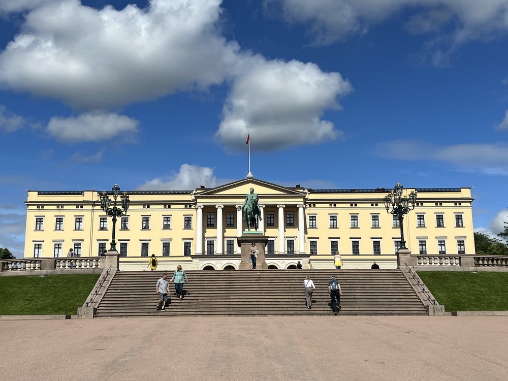
Where to stay — the best spot to stay is central Oslo, near Karl Johans gate. From there, you can easily walk to the Royal Palace, National Theatre, Oslo Cathedral, and many museums and galleries. Most top attractions are close together.
DAY 13
Depart for home or another European destination.


Average cost:
(EXCLUDING AIRFARE)
$$$ USD for two (2) people
Budget: $5,000
Moderate: $7,500
Luxury: $9,500 +

Search for your hotel

🌤️ Climate
The best times to visit Lofoten for ideal weather are from June 11th to August 26th.
The coldest season/winter is January, February, March, and December.
October tops the wettest month list with 142mm (5.6in) of rainfall.
July is the driest month with 65mm (2.6in) of precipitation.
June is the sunniest month with an average of 222 hours of sunshine.
From roughly late May to mid-July, the sun never sets below the horizon. Instead of rising and setting, the sun dips toward the horizon at midnight and ascends again, casting a continuous golden-hour glow.


Norway Gallery
🎬 Video


No copyright infringement is intended on this website by travelwildnow.com
Sources: Earth Trekkers