
ARGENTINA - PATAGONIA 5 Days
This itinerary visits the tourist town of El Calafate, home to Los Glaciares National Park and the massive Perito Moreno Glacier, Lago Argentino, and the famed Fitz Roy Trek.
Patagonia is a mostly empty region in the southern part of South America, shared by Argentina and Chile. Argentina’s side has dry plains, grasslands, unique animals like Magellanic penguins on small islands, and whale watching. The famous National Route 40 runs by Monte Fitz Roy and the growing Perito Moreno Glacier in Los Glaciares National Park.
Patagonia is also the gateway for cruises to Antarctica.

ℹ️ Essential Tips:
Patagonia is the perfect area for a self-drive adventure.
This remote region is generally very safe for tourists, and with normal safety precautions, you should have no problems navigating the region. Renting a car to explore is the best way.
Travel Adaptors for Argentina: Type C (Patagonia region) and Type I
Visa Info: U.S. and Canadian citizens do NOT need a visa to enter Argentina.
Flight Info: There are NO direct international flights to Patagonia; connect via Buenos Aires.
Planning resources available on the [South America tourism website]
Travel Guides: Lonely Planet Argentina and Moon’s Patagonia.

<Zoom in>

DAY 1
Arrive in El Calafate, Argentina, and transfer to your hotel.
There are direct flights from Buenos Aires to El Calafate on a daily basis.
The main artery in El Calafate is Del Libertador Avenue (Main St.).
Here you will find the main stores, restaurants & coffee shops, plus the travel agencies. [List]
🚗 Car rental and transportation information:
Renting a car, preferably a 4x4, is your best option. Although bigger roads in Patagonia are well paved, you will find many roads (such as the roads into the national parks) are gravel and dirt.
For visitors arriving at the airport, the car rental offices are located in the terminal.
Visitors arriving by Bus from Chile—the car rental offices are located on Del Libertador Avenue (Main St.)
Taxis are available at the bus terminal to transfer you to the Main St. offices.
Overnight: El Calafate (2 nights)
DAY 2
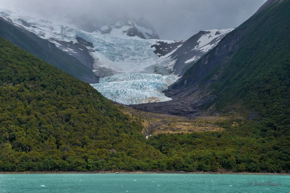
The best way to exploreParque Nacional Los Glaciares is by boat, home to 47 colossal glaciers.
Massive glaciers of incredible beauty, such as Upsala, Perito Moreno, and Spegazzini, are located here.
After Antarctica, the southern Andes are home to the largest area covered by ice in this hemisphere.
Experience the Majesty of a Lago Argentino Glacier Cruise.
Embark on an 8-hour journey departing from Punta Bandera.
Witness the beauty of the Splegazzini Glacier, the expansive Lago Argentino, and the inspiring Upsala Glacier, the largest ice cap in South America.
Departure Details:
Location: Punta Bandera Port. [directions]
Distance from El Calafate: 47 km west, 50 minutes.
GPS Coordinates: 50°18'04.5"S 72°47'57.6"W.
All hotels and tour operators offer booking services for the cruise.
Overnight: El Calafate

DAY 3
Journey to Perito Moreno Glacier.
Allow 90 minutes each way from El Calafate.
Perito Moreno - is one of only three glaciers in the world that grow rather than retreat. Best known for the dramatic icefalls from its front wall into Lake Argentino. The glacier is 30 km in length and 5 km wide at the face. Photo opportunities abound.
Accessing the Viewing Platform:
Park your car at the end of the road.
Access to the viewing platforms is through an easy boardwalk walk.
Exploring the Walkways:
The walkways offer multiple routes and directions.
Various viewpoints and balconies are strategically placed along the walkways.
Enhanced Viewing Experience:
These viewpoints and balconies provide the best views and perspectives of the glacier.
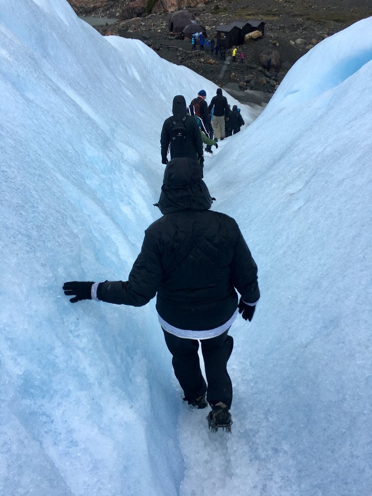
A more rewarding activity is booking the“Ice Glacier Walk”.
[Book with Hielo & Aventura] The walk is a trek along the glacier. You will witness turquoise ponds, deep cracks, and more. At the end of the amazing walk, you will enjoy a whisky on the rocks while taking in the views.
To have an excellent experience in the Glacier, visitors must have sufficient physical capacity to walk for 3 hours, of which 60 to 90 minutes is on the ice and with crampons.
FAQ’s about the Ice Glacier Walk.
Boats depart from the “Bajo de las Sombras” Port, which is about 70 km from El Calafate on Route 11. [directions]
-
What to take during the summer months:
Compared to city trips, you need to pack more functional clothes due to the weather conditions, which can change quickly in this region.
You should invest in some good outdoor clothes that are comfortable but also easy to handle.
Plan for only a few days, after or in between washing your clothes – this ensures to pack lightly.
A great app for mapping your hike is Alltrails.
T-Shirts (mid-layer) – We recommend using breathable sport shirts.
Hiking Pants, with the option to turn into short pants.
Rain Pants strongly recommended.
Fleece Jacket (mid layer) – highly recommended for colder parts and the evenings!
Breathable, waterproof Jacket as a shell layer or a light Rain jacket.
Scarf – for cold and windy parts.
Warm Hat.
Sun glasses very important not to forget.
Good Hiking Boots, preferably waterproof.
Hiking poles, can be very helpful.
Trekking Backpack – i.e. 50l internal frame backpacks are great for multiple day hikes.
Hiking Daypack, if you plan short hikes.
Drybag – keeps your technical equipment dry.
ZipLocs, helps you organizing.
Energy Bars.

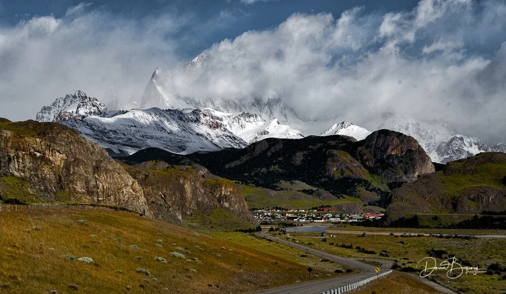
In the afternoon, depart for El Chalten. [visitor information]
The town is the gateway to the nearby Mount Fitz Roy and the path leading to the Laguna de los Tres viewpoint.
The drive to El Chalten is spectacular.
One of the highlights in El Chalten is to stay at an Estancia. Experience the rural culture of a traditional estancia, complete with a horseback ride in wide-open spaces with stunning views. <Add an extra day>
Estancia La Quinta and Estancia La Estela are 2 favorites near town.
Overnight: El Chalten (2 nights)
Distance:
El Calafate ---> Puerto Moreno Glacier [Bajo de las Sombras Port.] 1.5 hr.
El Calafate ---> El Chaltén, 3.5 hrs.
DAY 4
Attempt the best hike in Argentina: the Fitz Roy Trek (Laguna de Los Tres)
It is advisable to start the trek as early as possible, between 7 am and 8 am, if the weather permits.
The trailhead begins at the end of Avenida San Martín, where the urban area of El Chaltén ends, and the car park is located.
The self-guided trek route is about 23 km (14 miles) RT and can be completed in 8-9 hours.
El Chaltén is the point of departure and return. Bring plenty of food and water. [Learn more]
Great app to download on any hike: [All Trails] [map]
Best time to do the Fitz Roy trek: In the summer between mid-October and early April.
Outside of summer, many of the restaurants and hotels are closed.
If you had to choose just one hike to recommend in Patagonia, it would no doubt have to be the Fitz Roy trek.
Overnight: El Chalten
DAY 5
Depart El Chaltén to El Calafate for your flight home or continue by bus to begin your Chile Patagonia Extension.
Distance: El Chaltén ---> El Calafate. 3.5 hr / 210 km.

A Special Place:

Luxury:Estrancia Cristina
Travelers can book multi-night stays or take full expeditions from El Calafate to Estancia Cristina <video>, a 20th-century sheep ranch only accessible by boat across Lake Argentino.
Set on 54,000 acres of wild Patagonian landscape, the preserved estancia offers excellent food, a list of excursions that combine trekking, 4x4, and sailing among icebergs near the Upsala Glacier. Lodging is in high-quality refurbished buildings where you can just sit back and enjoy the stunning scenery. Fishermen, meanwhile, can ride horseback to glacial lakes near the hotel to catch Chinook salmon and rainbow trout.

Noteworthy advice for traveling between ARGENTINA and CHILE
<Route>
Many people travel from/to El Calafate, ARGENTINA, to Puerto Natales, CHILE, to visit Torres del Paine National Park.
There is NO AIR SERVICE between El Calafate and Puerto Natales.
The only practical and easiest way is by bus.
One-way car rentals are extremely expensive.
LEG 1:
You can take the Bus from El Calafate, Argentina, to Puerto Natales, Chile.
It’s about 350km (210 miles) and takes ~ 5 hours, including the border documentation CHECKPOINT.
🚌 Bus operators serving the El Calafate - Puerto Natales route:
* * * * * * * * * * * * * * * * *
LEG 2:
From: Puerto Natales to Torres del Paine National Park: ~ a 90-minute drive.
Options:
A. Car rentals are available in Puerto Natales. It’s your best flexibility.
B. Bus companies run to Torres del Paine twice daily (departures: ~7:30 a.m. & 2:30 p.m.) Check for return times.
C. Hotel pick-ups available (usually more expensive).
Petro Alert: There are NO Gas Stations north of Puerto Natales.
CLOSEST AIRPORT to Torres del Paine, Punta Arenas Airport, 5 hrs. away; and Puerto Natales (seasonal), 1.5 hrs.


ADD CHILE
SOUTH PATAGONIA


-
1. Is Patagonia a safe area?
There are NO serious security problems in Patagonia. The greatest risks are associated with isolation. If traveling by car make sure you do have the amount of fuel needed to reach your destination. Gas stations can be far. In Torres del Paine, there are no gas stations. Puerto Natales, 90 miles away, is the closest.
2. Is there a risk of strange diseases in Patagonia?
Patagonia is an endemic disease-free zone, so no special vaccinations are needed to travel. No increased risk of health problems.
3. Are there any poisonous animals in Patagonia?
Patagonia has no snakes or dangerous wild animals, making it safe for visitors to enjoy outdoor activities.
4. Do I need a passport or visa to enter Patagonia?
Visas are not required for entry to Chile or Argentina for citizens of the USA & most European countries as well, if you are going to stay up to 90 days.
5. What is the voltage of the electricity supply in Patagonia? Do I need to take a converter?
Electricity is supplied throughout Patagonia at 230/240 volts ( Type C ). For all other equipment, an adapter/converter is necessary, unless the item has a multi-voltage option.

Search your hotel


Average Cost:
(EXCLUDING AIRFARE)
$$$ USD for two (2) people.
Budget: $1,300
Moderate: $1,650
Luxury: $2,100 +

🌤️ Climate Guide:
The best times to visit are mid-October through February (springtime & summertime in the southern hemisphere).
Cloudy days are very common around the glaciers and mountains.
The warmest months are December through February.
The coolest month is July.
May is the wettest month.
December & November are the driest months.

Patagonia Gallery
🎬 Video


Sources: wikipedia.org, solo patagonia tours, Parque Nacional Los Glaciares, Foton.No copyright infringement is intended on this website by travelwildnow.com